
Daya Sagar
To many the Indian ‘State’ of Jammu and Kashmir is even this day ‘known’ as Kashmir. In pre 1947 British times too the Princely State of Jammu and Kashmir was also referred as Kashmir even in official quotes and such like references have made many to feel/believe that Jammu and Kashmir State prominently comprises of Kashmir Valley only where as the Kashmir Valley is a small part of Jammu and Kashmir State. A brief review of the Geo -Administrative order of Maharaja Hari Singh’s Princely State of British Indian Empire would give some meaningful understanding about Jammu and Kashmir State &affairs related this most discussed { even internationally} Indian state .In the nineteenth century Maharaja Gulab Singh of Jammu & Kashmir ventured into marking the Geographical boundaries of Bharat to the other side of Himalayas . Gulab Singh’s forces even routed the ‘Tibetian’ army. Raja Gulab Singh’s General Zorabar Singh had followed the route through Kishtwar in 1830’s since at that time Kashmir valley was not governed by Gulab Singh.. Jammu Region and Ladakh region were already part of Jammu Raj before the control of the Kashmir Valley was also transferred to Jammu Raj { Maharaja Gulab Singh } by the British India Crown when the Kashmir valley was surrendered to the British India by the Punjab Sikh Empire as compensation for the battle the Sikhs lost to the British in 1846. Hence the Jammu Raj was named as the State of Jammu and Kashmir.
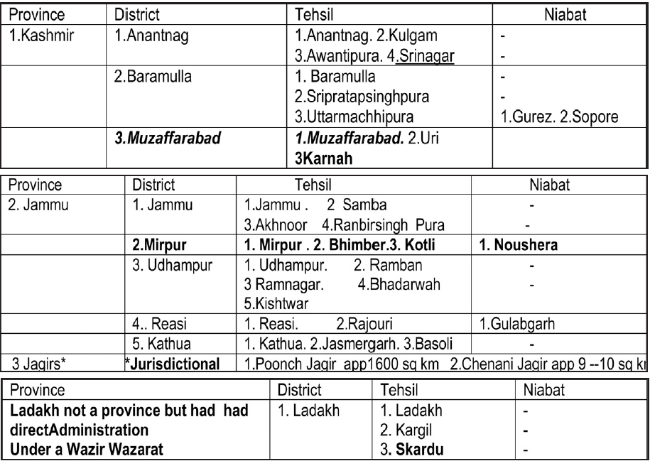
A fair and honest trial could be done by looking at the structure of Civil Administration given to J&K by the times of Maharaja Hari Singh before when the then Princely state of J&K acceded to India Dominion on 26th Oct 1947 to become part of India i.e Bharat Democratic Republic. Civil Divisions / Administration For the purposes of civil administration, the state was divided into three parts ; 1. Province of Jammu [ app 14010 sq Miles(12401+1600+9) /36315 Sq Km } 2. Province of Kashmir { 8569 sq miles / 22133sq Km} 3. District of Ladakh. The head of revenue administration in each province was a Governor.. Ladakh district was under a Wazir Wazarat. Kashmir Province: { 8569 sq miles / 22000sq Km} : The Geographical Division of J&K comprising of the Jhelum valley (consisting of the valleys that drained into the Jhelum and Krishan Ganga rivers ) and the lateral valleys of the Sind as well as that of Liddar together form the famous Kashmir valley. Kashmir Valley along with the hilly track of Muzaffarabad included in Kashmir Province. It is the Kashmir Region of today.
Jammu Province: { app 14010 sq Miles /36315 Sq Km } . It extended over the Semi- mountainous and Sub-mountane tract consisting of the plains contiguous to the Punjab and broken Kandi country skirting the
Himalayan ranges. The rivers Ravi, Chenab, and Jhelum and several perennial streams flowing through. The hills in Bhaderwah, Doda, and Kishtwar formed part of this Division. Jagirs of Poonch & Chenani too were with this Province. This Division comprised the whole area covered by the ranges of low hills to the south of Pir Panjal Mountains which divide the two provinces of Jammu and Kashmir.
District of Ladakh {63554 sq miles / 164748 sq km }:- The Tibetian and Semi Tibetian tract, that consisted on middle reaches of the Indus formed this Division i.e Ladakh DISTRICT OF Maharajas Administration comprised of district of Gilgit and the frontier illaquas of Skardu, Ladakh and Kargil. The river Indus having it’s source in Mansarovar lake in Tibet traversed the whole of this Division (district} running from south east up to the bend around the Nanga Parbat, where it assumes a south westerly course. Except in Gilgit, the ranges in this Division Vary from17000 feet to 22000 feet. . Crop area in Ladakh was very small. Mountains in the North stretch up to Pamirs. Mount Godwin Astin, 28265 feet above MSL was the then second highest known peak in world. Bhotia and Shina spoken in Ladakh and Gilgit remained confined to Ladakh .
# Astore was under a Revenue Assistant and ## Ladakh had nearly Direct Administration under a Wazir Wazarat. In 1935 when Soviet Russia nearly over ran Eastern Turkistan , the British executed an agreement with Maharaja Hari Singh and took Gilgit on lease under which the administration and defence of Gilgit became the subject of the British. An irregular corps , the Gilgit Scouts was raised for the purpose. In 1947 Gilgit was administratively/ technically transferred back to Maharaja. Frontier illaqas of Skardu , Ladakh and Kargil was 63554 square miles (approximately 1,65000 square kilometers). The population was very sparse. In Jammu Province of erstwhile Princely State of Maharaja Hari Singh the Muslim formed a large portion of population but the Jammu Province still extended over larger part of the domain as compared to Kashmir Province without any communal overtones and considerations. Where as a just and rational segmentation of the civil administration was there looking at the ethnic/ cultural /geographical physicals for the welfare of the masses which had been the prime consideration with Maharaja. On the whole the Muslim population was nearly 77 % of total population of the State as per 1941 census
In 1947 /48 Pakistan by way of illegal infiltration/ attack in the disguise of tribal attack involving regular defence forces encroached upon some parts of Mirpur district, some part of Poonch Jagir,some parts of Ladakh Wazarat/ Gilgit Baltistan and the areas are still under Pakistan occupation since India in Jan
1948 in the interest of peace in the two Dominions of India & Pakistan that had just attained independence requested UNO to impress upon Pakistan refrain from illegal intrusions & clear the invaded areas of Indian state of J&K. but UNO have not been able perform the duty till date. So in to be brief Jammu Province / Jammu Region/Jammu Division had 5 Districts ( Mirpur, Jammu, Kathua,Udhampur & Reasi) and two Jagirs ( Poonch & Chenani) out of which Mirpur District & some parts of Poonch Jagir remained under Pakistan occupation leaving nearly four Districts & two Jagirs in Jammu region where in the Kashmir Region there were three districts ( Anantnag, Baramulla & Muzaffrabad) out of which almost all District of Muzaffrabad had been occupied by Pakistan leaving behind only about Districts. As regards the Ladakh Division/ Wazarat Gilgit/ Baltistan area was illegally encroached by Pakistan. Accordingly the areas excluding the areas were reorganised in terms of district administrative units as Jammu Region ( Nearly 4 districts & 2 Jagirs ) in 6 districts ( Poonch, Rajouri, Jammu, Kathua,Udhampur ,Doda ) extending over an areas of around 26293 Sq Km with more rough/ bad terrain; as Kashmir Region ( 2 Districts ) in 3 Districts (Anantnag, Srinagar,Baramulla ) extending over an area of around 15948 sq Km mostly plain & easy terrain and Ladakh region as 1 district. That means Admistration of J&K in independent India started with 6 Districts in Jammu Region (26293 sq km),3 Districts in Kashmir region (15948 sq km) and 1 Region in Ladakh region. It was in1979 that Districts in Kashmir region were increased from 3 ( Srinagar, Anantnag, Baramulla ) to 6 ( Srinagar, Badgam, Anantnag Pulwama,Baramulla,Kupwara ) by then Government vide by SRO 306 of 6/6/1979, districts in Ladakh region were increased from 1( Leh) to 2 ( Leh, Kargil) where as the districts in Jammu region were kept 6 only ( no increase) as it was there. It was in 2006/07 that Congress lead Congress-PDP government during UPA-I times once again so irrationally carved out ( in 2006-07 vide SRO 185 of 22 May 2007 ) 4 new districts in Kashmir valley as against only 1 recommended by Wazir Commission (MC) in 1984 i.e 300 % more than recommended by WC and also only 4 new districts in Jammu region as against 3 already recommended by WC in 1984 i.e only 33 % more than what was recommended by WC in 1984. So both Jammu Region as well as Kashmir Region in 2026 have 10 District Administrative units when in 1978 Kashmir region had only 3 districts and Jammu region had 6 regions. So any analysis as regards investments & development that will have to be made must be done keeping in view the number of districts as were there in 1978.. Since the common man has very less information and is innocent, some have succeeded in even terming the demand for separate State of Jammu { extending over the territories of Jammu Province of the State of Jammu and Kashmir as a Hindu dominated area demand ,which is surely a wrong propaganda.
(The writer is Sr Journalist and social activist)